一、简介1.在移动互联网时代,移动app能解决用户的很多生活琐事,比如
(1)导航:去任意陌生的地方
(2)周边:找餐馆、找酒店、找银行、找电影院
2.在上述应用中,都用到了地图和定位功能,在iOS开发中,要想加入这2大功能,必须基于2个框架进行开发
(1)Map Kit :用于地图展示
(2)Core Location :用于地理定位
3.两个热门专业术语
(1)LBS :Location Based Service(基于定位的服务)
(2)SoLoMo :Social Local Mobile(索罗门)
二、CoreLocation框架的使用1.CoreLocation框架使用前提
(1)导入框架
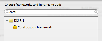
说明:在Xcode5以后,不再需要我们手动导入
(2)导入主头文件
复制代码 代码如下:#import <CoreLocation/CoreLocation.h>
2.CoreLocation框架使用须知
CoreLocation框架中所有数据类型的前缀都是CL
CoreLocation中使用CLLocationManager对象来做用户定位
三、经纬度等地理信息扫盲1.示意图
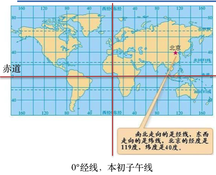
2.本初子午线:穿过英国伦敦格林文治天文台
往东边(右边)走,是东经(E)
往西边(左边)走,是西经(W)
东西经各180°,总共360°
3.赤道:零度维度
往北边(上边)走,是北纬(N)
往南边(下边)走,是南纬(S)
南北纬各90°,总共180°
提示:横跨经度纬度越大(1° ≈ 111km),表示的范围就越大,在地图上看到的东西就越小
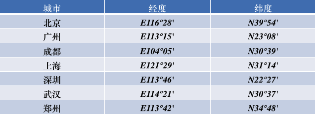
4.我国的经纬度:
(1)中国的经纬度范围
纬度范围:N 3°51′ ~ N 53°33′
经度范围:E 73°33′ ~ E 135°05′
(2)部分城市的经纬度
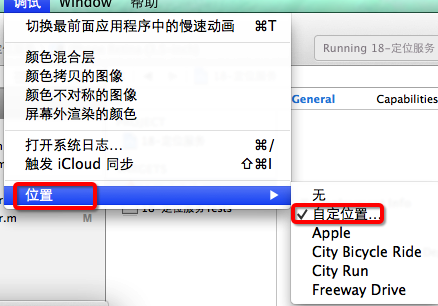
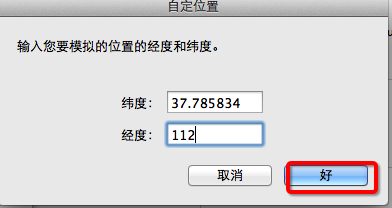
 四、模拟位置
说明:在对程序进行测试的时候,设置手机模拟器的模拟位置(经纬度)
 CoreLocation地理编码
一、简单说明CLGeocoder:地理编码器,其中Geo是地理的英文单词Geography的简写。
1.使用CLGeocoder可以完成“地理编码”和“反地理编码”
地理编码:根据给定的地名,获得具体的位置信息(比如经纬度、地址的全称等)
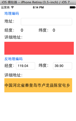
反地理编码:根据给定的经纬度,获得具体的位置信息
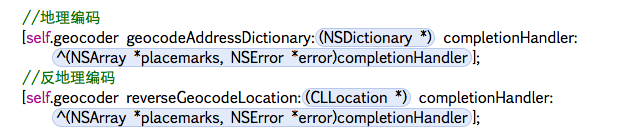
(1)地理编码方法
复制代码 代码如下:
- (void)geocodeAddressString:(NSString *)addressString completionHandler:(CLGeocodeCompletionHandler)completionHandler;
(2)反地理编码方法
复制代码 代码如下:
- (void)reverseGeocodeLocation:(CLLocation *)location completionHandler:(CLGeocodeCompletionHandler)completionHandler;
2.CLGeocodeCompletionHandler
当地理反地理编码完成时,就会调用CLGeocodeCompletionHandler
这个block传递2个参数
error :当编码出错时(比如编码不出具体的信息)有值
placemarks :里面装着CLPlacemark对象
3.CLPlacemark
说明:CLPlacemark的字面意思是地标,封装详细的地址位置信息
地理位置 @property (nonatomic, readonly) CLLocation *location;
区域 @property (nonatomic, readonly) CLRegion *region;
详细的地址信息 @property (nonatomic, readonly) NSDictionary *addressDictionary;
地址名称 @property (nonatomic, readonly) NSString *name;
城市 @property (nonatomic, readonly) NSString *locality;
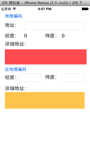
二、代码示例:在storyboard中搭建界面如下:
实现代码:
复制代码 代码如下:
YYViewController.m文件
//
// YYViewController.m
// 19-地理编码
//
// Created by apple on 14-8-11.
// Copyright (c) 2014年 yangyong. All rights reserved.
//
#import "YYViewController.h"
#import <CoreLocation/CoreLocation.h>
@interface YYViewController ()
@property(nonatomic,strong)CLGeocoder *geocoder;
#pragma mark-地理编码
- (IBAction)geocode;
@property (weak, nonatomic) IBOutlet UITextField *addressField;
@property (weak, nonatomic) IBOutlet UILabel *longitudeLabel;
@property (weak, nonatomic) IBOutlet UILabel *latitudeLabel;
@property (weak, nonatomic) IBOutlet UILabel *detailAddressLabel;
#pragma mark-反地理编码
- (IBAction)reverseGeocode;
@property (weak, nonatomic) IBOutlet UITextField *longitudeField;
@property (weak, nonatomic) IBOutlet UITextField *latitudeField;
@property (weak, nonatomic) IBOutlet UILabel *reverdeDetailAddressLabel;
@end
复制代码 代码如下:
@implementation YYViewController
#pragma mark-懒加载
-(CLGeocoder *)geocoder
{
if (_geocoder==nil) {
_geocoder=[[CLGeocoder alloc]init];
}
return _geocoder;
}
- (void)viewDidLoad
{
[super viewDidLoad];
}
/**
* 地理编码:地名—>经纬度坐标
*/
- (IBAction)geocode {
//1.获得输入的地址
NSString *address=self.addressField.text;
if (address.length==0) return;
//2.开始地理编码
//说明:调用下面的方法开始编码,不管编码是成功还是失败都会调用block中的方法
[self.geocoder geocodeAddressString:address completionHandler:^(NSArray *placemarks, NSError *error) {
//如果有错误信息,或者是数组中获取的地名元素数量为0,那么说明没有找到
if (error || placemarks.count==0) {
self.detailAddressLabel.text=@"你输入的地址没找到,可能在月球上";
}else // 编码成功,找到了具体的位置信息
{
//打印查看找到的所有的位置信息
/*
name:名称
locality:城市
country:国家
postalCode:邮政编码
*/
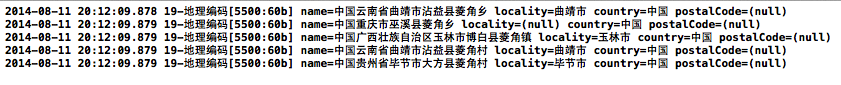
for (CLPlacemark *placemark in placemarks) {
NSLog(@"name=%@ locality=%@ country=%@ postalCode=%@",placemark.name,placemark.locality,placemark.country,placemark.postalCode);
}
//取出获取的地理信息数组中的第一个显示在界面上
CLPlacemark *firstPlacemark=[placemarks firstObject];
//详细地址名称
self.detailAddressLabel.text=firstPlacemark.name;
//纬度
CLLocationDegrees latitude=firstPlacemark.location.coordinate.latitude;
//经度
CLLocationDegrees longitude=firstPlacemark.location.coordinate.longitude;
self.latitudeLabel.text=[NSString stringWithFormat:@"%.2f",latitude];
self.longitudeLabel.text=[NSString stringWithFormat:@"%.2f",longitude];
}
}];
}
/**
* 反地理编码:经纬度坐标—>地名
*/
- (IBAction)reverseGeocode {
//1.获得输入的经纬度
NSString *longtitudeText=self.longitudeField.text;
NSString *latitudeText=self.latitudeField.text;
if (longtitudeText.length==0||latitudeText.length==0) return;
CLLocationDegrees latitude=[latitudeText doubleValue];
CLLocationDegrees longitude=[longtitudeText doubleValue];
CLLocation *location=[[CLLocation alloc]initWithLatitude:latitude longitude:longitude];
//2.反地理编码
[self.geocoder reverseGeocodeLocation:location completionHandler:^(NSArray *placemarks, NSError *error) {
if (error||placemarks.count==0) {
self.reverdeDetailAddressLabel.text=@"你输入的地址没找到,可能在月球上";
}else//编码成功
{
//显示最前面的地标信息
CLPlacemark *firstPlacemark=[placemarks firstObject];
self.reverdeDetailAddressLabel.text=firstPlacemark.name;
//经纬度
CLLocationDegrees latitude=firstPlacemark.location.coordinate.latitude;
CLLocationDegrees longitude=firstPlacemark.location.coordinate.longitude;
self.latitudeField.text=[NSString stringWithFormat:@"%.2f",latitude];
self.longitudeField.text=[NSString stringWithFormat:@"%.2f",longitude];
}
}];
}
-(void)touchesBegan:(NSSet *)touches withEvent:(UIEvent *)event
{
[self.view endEditing:YES];
}
@end
实现效果:
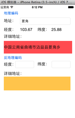
(1)地理编码:(地名->经纬度坐标)
打印输出:
(2)反地理编码:(经纬度—>地名)
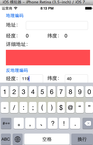
(3)注意:调整键盘
点击经纬度textField进行输入的时候,弹出的键盘如下
(4)注意:搜索的所有结果都是在中国境内的,因为苹果在中国的地图服务商是高德地图。